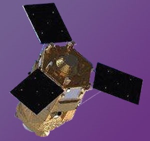
Morocco’s Mohammed VI-B Earth Observation Satellite Due To Be Launched By Arianespace In November 2018
PERSISMA, Rabat – Morocco, thanks to the Enlightened Vision of OUR AUGUSTE SOVEREIGN, being the first country in Africa to hold a constellation of Earth observation satellites at very high resolution. The MOHAMMED VI-B satellite will be managed, as well as the MOHAMMED VI-A satellite, by Moroccan engineers and technicians, who have benefited from long specialized training, both in Morocco and abroad.
Moroccan media announced that the second high-resolution Earth Observation satellite of the North African country, Mohammed VI-B, is expected to be launched on an Arianespace launcher from the Kourou Space Center in French Guiana in November 2018. , on the Vega or the Soyuz. ST-A Fregat-M satellite launchers.
The launch of Mohammed VI-B is expected to take place one year after the successful launch of Morocco’s first Earth observation satellite, Mohammed VI-A, also by Arianespace.
The Mohammed VI-B satellite, like the Mohammed VI-A satellite, is based on the Pleiades-HR high-resolution Earth observation satellite. The Mohammed VI satellite, the two satellites, would have a panchromatic resolution of 50 centimeters.
The second satellite “Mohammed VI B” is almost ready to join its twin brother “Mohammed VI-A” in November 2018. This satellite aims mainly to glean information both in the strategic area (water and water management, Agriculture).
Contribution
Their contribution in the following areas:
The cadastre and the cartography. topographic mapping of the whole national territory and its daily update, cadastral works, in particular, land parcels surveys.
Agriculture. survey of farmlands by thematic cartography, soil fertility assessment, diagnosis of the state of cultivations in order to improve and optimize the farmer’s performance, irrigated zone mapping, agricultural campaigns monitoring.
Water resources. water surface identification and humid areas cartography, monitoring of beach erosion, quantification of water volumes in lakes and dams.
Building and Public Works and Transport. Inspection of art works and linear works, monitoring of construction progress, transportation route’s localization and optimization…
Forestry. forest species mapping and forest inventory updating, forest burned areas mapping…
Mines and geology. Geologic mapping of mining deposits and the assessments of their extents, geological structures analysis, mining exploration.
Communication networks. Establishment of updated cartographic backgrounds, for the visualization of road and rail networks.
Monitoring of major projects. Mapping of major projects and monitoring of the progress of their achievement (solar power plants, wind farms, dams and other infrastructural projects)…
Urban and land use planning. Monitoring the evolution of the urban districts and peripheral areas, control of the substandard housing, land-use plans, mapping of land-use and the monitoring of desertification.
Oceanography and coastal areas. Support the exploitation, the planning and the integrated management of the oceanographic spaces, the littoral and the coastal areas. Contribute in shaping master plans and costal planning.
Natural Catastrophies. Assist in case of a natural catastrophy, cartography of disaster areas, floods, fires, earthquakes.
Borders and littoral surveillance. littoral’s planning, analysis of the evolution of soil occupation, impact of harbors on their environment, illegal migration flux.


New Comments