The goals of the Launch of MOHAMMED VI-B satellite
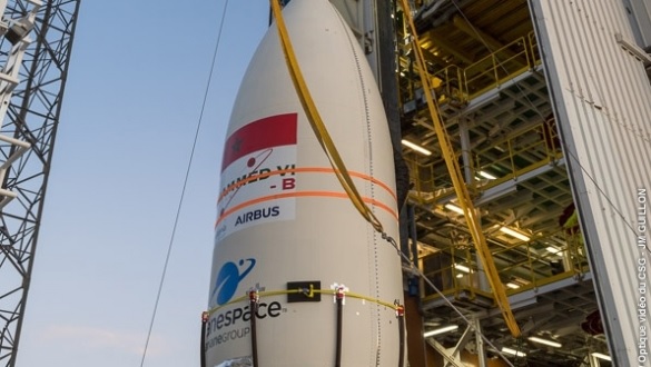
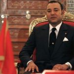
PERSISMA, Rabat – The satellite MOHAMMED VI-B is the second satellite of the space program decided by HIS MAJESTY THE KING MOHAMMED VI, in 2013. The realization of this program was entrusted to the consortium Thales Alenia Space and Airbus. It is spread over a period of five years.
As a reminder, the first satellite, MOHAMMED VI-A, was launched on 8 November 2017 by the Vega rocket from the Kourou launch site in French Guiana.
The second satellite, MOHAMMED VI-B, is scheduled to be launched on 21th November 2018. Both of satellites can take very high resolution images. In particular, their complementarity allows a significant reduction in revisit time.
The MOHAMMED VI-B satellite will be fully managed, as well as the MOHAMMED VI-A satellite by Moroccan engineers and technicians who have benefited from long specialized training, both in Morocco and abroad.
Exploitation of satellite imagery is becoming more and more essential in several areas including: cadastre and cartography, agriculture, water resources, building and public works (construction and public works) and transport, water and forests, mines and geology, communications networks, monitoring of major projects, urban and regional planning, oceanography and coastal zones, natural disasters…
The following file details some areas of application of satellite imagery.
MAIN AREAS OF APPLICATIONSATELLITE
IMAGESAGRICULTURE
Agriculture is a key sector in the economic, social and environmental development of Morocco. The increase in production and the improvement of agricultural productivity, strategic objectives of the national agricultural policy, have to face many challenges: impacts of climate change, scarcity of water resources, soil degradation, and pressure of the urbanization…
MAPPING OF IRRIGATED CROPS
The need for irrigation information is becoming increasingly important for assessing and monitoring water use and efficiency by crops.
OPERATIONAL MANAGEMENTIRRIGATION BASED ON SATELLITE MEASUREMENTS
In Morocco, the optimization of water supplies for irrigation is a critical need, particularly in arid and semi-arid regions, characterized by scarcity of water resources and adverse climatic conditions.
ELABORATION OF INDICATORS
FOLLOW-UP TO THE AGRICULTURAL CAMPAIGN
The availability of information through a set of indicators on the cropping season is very useful for the evaluation of the course of the cropping season. These indicators are extracted from a sample of very high resolution images representative of cereal crops taken at key stages of crop development.
IMPACT STUDY OF URBANIZATION
ON AGRICULTURAL LAND
Mapping the evolution of the urbanized space and its impact on agricultural land allows managers to better appreciate the trends of urban evolution and the nature of changes in agricultural spaces in favour of urbanization as well as qualitative rather than quantitative plans.
FOREST RESOURCES
Morocco is characterized by a great bio ecological diversity and a large number of natural environments. Forest formations are the founding element of this ecological and ecological wealth.
Play an important role both in economic activity and in the national strategy for sustainable development.
MAPPINGAND INVENTORY OF FOREST RESOURCES
The forest map is a tool for planning and managing forest resources at the national and local levels.
The National Forest Inventory (NFI) map is used both by the internal services of the Office of the High Commissioner for Water and Forests and the fight against desertification for the purposes of forest resources management and monitoring, as well as by all the departments concerned by the management of the territory.
MONITORING ACTIVITIES AND RISKS
FORESTRY, CUTTING, REFORESTATION, FOREST LIGHTS
The monitoring of the forest dynamics by remote sensing space is a necessary tool to better manage this natural area, in particular the identification and planning of logging and reforestation, the monitoring of the evolution of the forest massifs and the evaluation of the surfaces of forests. Different forest species disappeared.
TERRITORIAL MANAGEMENT
National spatial planning and the efficient management of territorial resources, whether economic, social or environmental, are at the centre of the overall development process.
CARTOGRAPHY FOR PLANNINGAND MONITORING URBAN AND COASTAL DEVELOPMENTS
Satellite imagery provides cartographic products at different scales of territorial intervention. It provides up-to-date information on urban tissue and other related themes and their spatial distribution.
MONITORING URBAN AND PERI-URBAN EXTENSIONS
Satellite images allow a better control of the occupation of space in urban and peri-urban areas through an updated knowledge of the urban fabric and its evolution over time.
OCEANOGRAPHY AND COASTAL ZONES
The Atlantic coast of Morocco, which stretches over 3500 km, is one of the richest coastal areas in terms of exploitable marine resources. The Moroccan Exclusive Economic Zone (EEZ) is characterized by a great diversity of fish resources encompassing nearly 500 species, 60 of which are exploited.
IDENTIFICATIONAQUACULTURE POTENTIAL OF COASTAL ZONES
The products derived from satellite images and in-situ measurements are combined to delimit and characterize the optimal areas for the installation of aquaculture farms to produce a cartographic database and an atlas with variable scales of indicators and parameters contributing in particular the success of aquaculture farms.
RESSOURCES HYDRIQUES
La gestion des ressources hydriques est devenue une problématique globale qui se trouve au centre de toutes les politiques de développement, aussi bien au niveau local qu’aux niveaux régional et international. En effet, l’eau est un facteur clé pour la sécurité alimentaire, la réduction de la pauvreté, l’amélioration de la santé des populations et le maintien des équilibres des écosystèmes et de la biodiversité.
SUIVI DES RESSOURCES EN EAU DE SURFACE
Dans certains cas, la délimitation de l’étendue de ces plans revête une grande importance pour l’évaluation de l’état des réserves en eau de surface. Les images satellitaires peuvent aussi être utilisées en vue d’analyser l’évolution dans le temps de ces plans et leur lien avec la variabilité spatio-temporelle des apports pluviométriques.
CARTOGRAPHIE ET SUIVI DES INONDATIONS
Les images satellitaires apportent des informations capitales pour la gestion et l’évaluation de l’impact des inondations. Dans le cadre de la gestion du risque d’inondation, l’imagerie satellitaire s’avère incontournable pour la cartographie précise de l’étendue des eaux et, par conséquent, la délimitation des zones sinistrées en période de crise.
GEOLOGIE ET RESSOURCES MINIERES
Les applications opérationnelles de l’observation de la Terre dans les domaines des sciences de la terre. La diversité des paysages géologiques du Maroc, ainsi que les potentialités en ressources minérales qu’offre le sous-sol national sont des ressources stratégiques dont la valorisation constitue une infrastructure géologique appropriée. Dans ce domaine, les images satellitaires s’avèrent essentielles au développement de la recherche minière et pétrolière, à l’évaluation des ressources en eau, à l’aménagement du territoire, à la protection de l’environnement, ainsi qu’à la prévention des risques naturels.
CARTOGRAPHIE GEOLOGIQUE
Le recours à l’imagerie satellitaire pour la reconnaissance des structures et de la lithologie des affleurements géologiques a toujours été d’une importance capitale pour le processus de la cartographie géologique.
Please visit us here; Contact us here
Brief note: This website is an official publication media of the organization of Indonesian Sahara Moroccan Brotherhood Association (Persisma – Persaudaraan Indonesia Sahara Maroko) based in Jakarta. Everyone can reach us via our contact above. We also welcome for all to contribute to build and develop such fraternity among Indonesian and Moroccan as well as other nations. Yes, this website is for you and the entire communities on this planet. Hopefully it will benefit for all. Thank you.
Marketing and Ads, please contact: +62-81371549165 (Mr. Shony)


 Baduy")

New Comments